Ever go swimming up in Shoot Brook? How about going up to the cabin on Prospect Lake? Are you concerned about what is going to happen to the old Tutor mansion on St. Anne’s Hill? Ever wonder who Hodges Hills was named after? What about Badger, there are no Badgers in Newfoundland, how did that place gets its name?
Old place names and maps are amongst my favorite research topics. Newfoundland is particularly rich in unique and obscure place names. There were so many duplicate, redundant and inappropriate place names on the island that at one time there was a nomenclature board that was tasked with renaming some of these communities. Central Newfoundland is probably not thought of as a place that is rich in old and forgotten place names, on closer inspection you will find that it is.
The first good accounts of Europeans coming into the Exploits Valley date from the 1700’s. Newfoundland had been visited and settled since the 1500’s but Notre Dame Bay and the Bay of Exploits was the Wild West, a land of Red Indians and Frenchmen. The area was part of the French Shore until 1789 and Britain and France were frequently at war.
In the latter half of the 1700’s English settlers and merchants started to take an interest in Notre Dame Bay, the French were being driven out and the lands were rich in salmon, fir and timber.
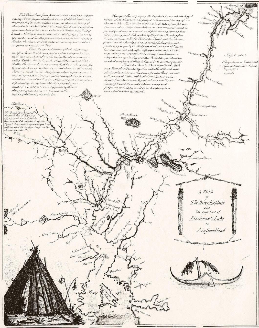
The first and best map that we have for this time comes from John Cartwright. John Cartwright was a Royal Navy Lieutenant who explored the Exploits River as far as Red Indian Lake. The purpose of this mission was, no doubt, to establish contact with the Beothuk people who were known to frequent the area. Cartwright did not meet any Beothuk (though he did see some of their houses, and it seems that this raised a bit of alarm), but he was able to traverse and map the river all the way to Red Indian Lake-which he named Lieutenants Lake.
Cartwrights map is a fascinating work to look at, but the available copies are quite hard to read. Surprisingly some of the place names present on the map survived the test of time. Peters River and Peters Arm at present day Peterview. Going further down the Exploits we come to Great Rattling Brook marked on today’s maps the same as it was in the 1770’s. The map gets a bit confusing because what became to be known as Bishop’s Falls is not clearly defined. Heading South West on the river you encounter Great Rattling Brook, Arrow Brook and Shoot Brook. Arrow Brook must be either Little Great Rattling or Greenwoods Brook. Shoot Brook is clearly Stoney Brook because of its proximity to “The Falls.” Above the falls at present day Grand Falls you came to “Nimrods Pool and Islands” which appear to have been located near Rushy Pond in the area of the current golf course.
Near Nimrods Pool was the outflow for Thunder Brook, yes Thunder Brook was the original name for Leech Brook (or is it Leitch Brook) the less appealing name coming in later years and more possibly as a result of a Surname rather than a blood sucking invertible.
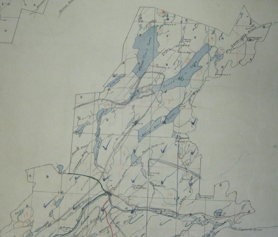
The falls on Thunder Brook famous to so many in Central Newfoundland appear to have flown out from “Mount Labour in Vain.” Apparently one of Cartwrights crew a Mr. Cousins climbed up this hill which offered a great view of the surrounding countryside. He was quite impressed that the area would be some prime beaver trapping grounds and was immediately disheartened when he saw several Beothuk camps in the area of what he called the “Forbidden Ponds.” I cannot fully figure out which Ponds were the Forbidden Ponds-from the map they look like they could be the ponds which Leech Brook Flow out of, possibly Aspen Pond or even Badger or Twin Lakes.
Strangely enough, Sandy Brook does not seem to be noted or named on the map, very odd considering its size. Further up river we come to one of the main tributaries encountered: Rangers River.
Over the years I have read a few different accounts of how Badger got its name. One story said an old MicMac trapper met another in the area and said he was as tired as a Badger. Another says it was from foremen badgering loggers in the camps. The more plausible story is this theory. Badger Brook is Rangers River and the name comes as a result of somebody misreading the old script on an old (most likely Cartwrights Map). The same goes for Badger Bay-which was thought to be the outflow for the Badger Brook watershed.

Some of the names on Cartwrights have held on to present day, but many have been changed over the years. There are a variety of sources which place names in the area came from. The most prevalent givers of names were the native peoples; the Micmac and to a lesser extent, Beothuk, some early explorers and settlers and loggers.
Hodges Hills were named for a very early settler in the Bay of Exploits, who came to the area sometime in the 1700’s, what happened to him is unknown (I may recall having read he had a run in with the Beothuk), but his name still graces a prominent landmark that can be seen for many kilometers.
The Micmac gave us many place names, many of which were drawn from personnel and family names. They include Noel Pauls Brook, John Paul’s Steady, Tom Joe Brook and possibly Pamehoc Brook. Added to that number most likely is St. Anne’s Hill. Where is St Anne’s Hill? You may ask. Well St. Anne’s Hill is the hill on which Grand Falls House is situated, it is marked as such on some old maps. This was likely named by the Micmac because St. Anne was their patron saint. Badger Lake or more properly the Badger Lakes, two of them are names for Micmac families-Paul’s and Joe’s Lakes.

Until the early part of the 20th Century many of the landmarks and bodies of water located at much distance from the Exploits were unknown and unnamed. As huge bodies of waters like Twin Lakes had yet to be mapped. Many areas of Central were virgin forest that may have been barely visited by the Beothuk or Micmac. But these areas had vast tracts of timber and as the wood close to the Exploits was cut loggers moved further and further inland. With the loggers came many unique place names.
In one little section of Sandy Badger most of the ponds were named by loggers in the middle of the twentieth century. They include Cripple Back Lake, Caribou Lake, Tobacco Pond, Mill Pond, Point of the Woods Brook, Island Pond, Lead Pond and Salt Pond. Mill Pond was named because a temporary sawmill was situated here in the 1950s and 60s operated by the AND Co for dam and camp construction. Salt Pond is reputedly named so because a sled with carrying a load of salt on it went through the ice. Caribou Lake was once named long lake, but loggers working there in the fifties renamed it despite the fact that the area is not known for a huge abundance of Caribou. One of the more humorous names in the area is Lead Pond, named because so many ducks have been shot at there, the bottom is covered in lead. I also recall that there is an Arsehole Pond up there somewhere, but I don’t think that that one has made it onto any topo-maps.

What about Catamaran Park/Brook. Most people think a catamaran is a type of boat. A lot of wood was cut, hauled and driven in the area and back in the old days a catamaran was a type of sled used to haul wood.
And I haven’t even scratched the surface with logging related place names having not gone into any depth with the various roads and campsites that are still referred to by locals, like Harold Stanley’s Camp’s, Amos Feeners Camps or 45 Mile.
Although Central Newfoundland was one of the lat areas in the province to be permanently settled, we do have over two hundred years of history in our interior nomenclature.
Another enjoyable and fascinating slice of Central history—well done! Re Hodges Hill–did it ever have another name? I recall reading in Cormack’s account of his search for the remaining Beothucks in 1827 or maybe 1828, that he referred to a prominent hill in that same area between the Exploits and the NE coast as “Hungry Hill”? My grandmother, who was from Laurenceton but lived all her adult life in GF, always called it Skull Hill.
LikeLike
I know there are hills with both those names. I think Skull Hill might be further Inland. I might have to follow up this one a bit. I forgot Badger lookout, Harpoon Hill, Harmsworth Steady and a host of others! What was your grandmothers maiden name? My wife is connected to Laurenceton.
LikeLike
Skull hill is located west of Badger.
LikeLike
Super Article; I’ve heard my Dad reference Horsehole Lake up Sandy Area. May be the Aresehole lake your referring to.
LikeLiked by 1 person
Might be, or a lake a horse fell into!
LikeLike
Hi
Are you aware of any mapping of Red Indian Lake done by Miller or his crew prior to major disturbance by the dams, perhaps when Millertown was being constructed?
LikeLike
I don’t have any. I am sure there is some. I have a 1905 map of Red Indian. I don’t think any of the damming Miller did changed the water much, I think it was more to keep logs out of the river.
LikeLike
Bryan:: my dad always told me that Joe’s Lake, Paul’s Lake and Crooked Lake we’re named after a well known contracter from Badger, J.P. Coleman, thus JPC.
LikeLike
I always thought they were named for the MicMac last names, both the Joe’s and the Paul’s trapped and lived in the area. But Coleman was one of the very first residents. He was manager of the sawmill there in 1905.
LikeLike